February 22, 2026
The metro stockholm map is your key to unlocking the Swedish capital, a city whose underground system is famous for being the "world's longest art gallery." It's all built around three main, colour-coded lines—Green, Red, and Blue—which make getting around the city surprisingly simple and quick. Learning to read this map is the very first step toward exploring Stockholm's unique neighbourhoods with confidence.
Welcome to the only guide you'll need for the Stockholm metro map, or Tunnelbana as you'll hear the locals call it. Think of this map as more than just a transit tool; it's your passport to adventure, connecting you to every corner of this stunning city built across 14 islands. Whether you're a first-time visitor trying to find your way to Gamla Stan or a seasoned traveller on the hunt for metro art, getting comfortable with the map is a must.
This guide is designed to help you feel like a local from your very first trip. We'll break down the system piece by piece, so you understand not just where the lines go, but how they connect to the city’s most important sights and hidden gems.
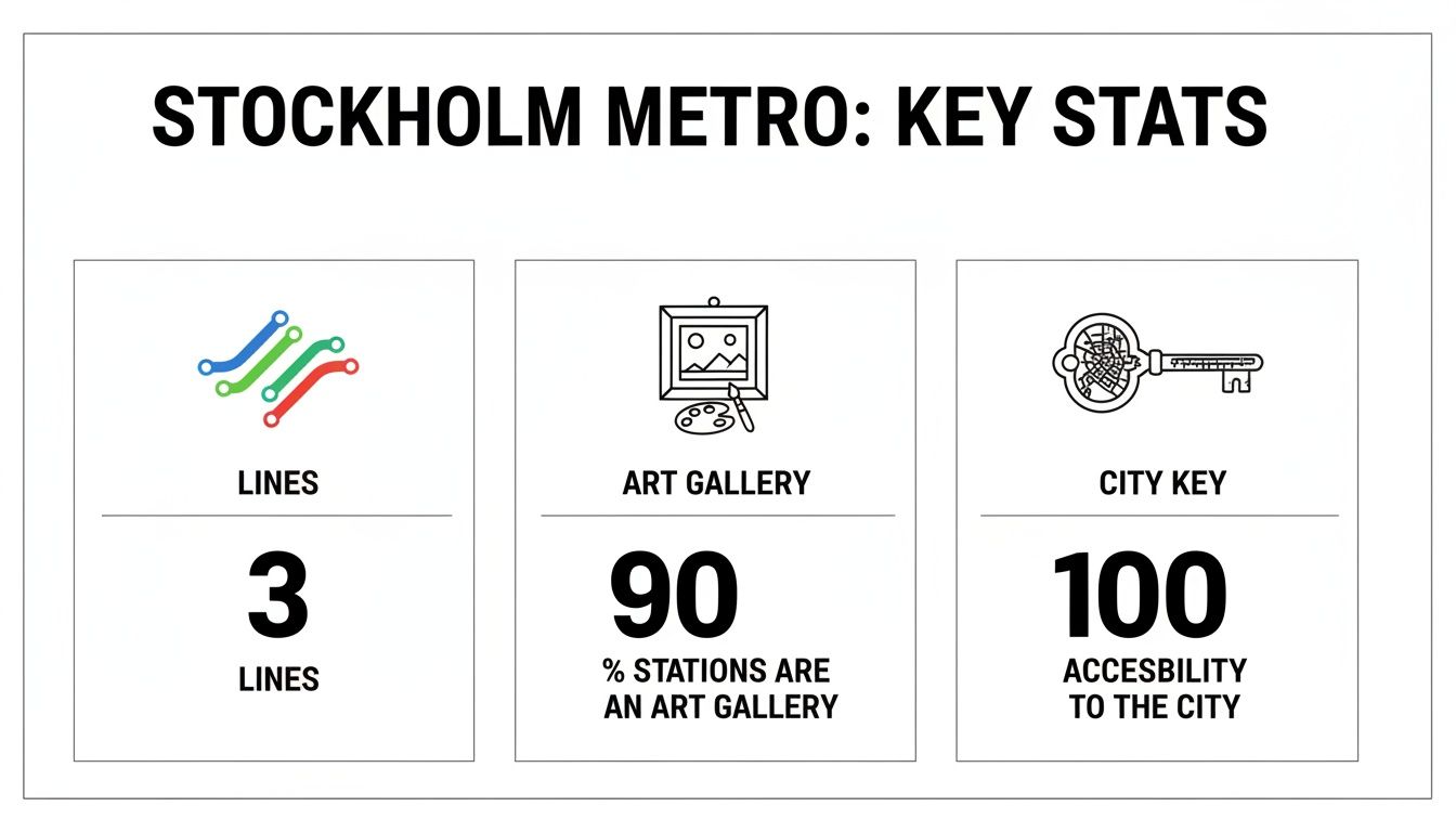
The Stockholm metro map is a brilliant example of Swedish design—clear, simple, and intuitive. But its real magic is what it represents: a gateway to an incredible public art project. In fact, nearly 90% of the 100 stations feature one-of-a-kind art installations, turning a daily commute into something special.
The map doesn't just show you how to get from point A to point B; it invites you on a journey through decades of public art and architectural innovation, making the metro itself a destination.
To get started, it's helpful to know the basic building blocks you'll find on any official metro stockholm map. The whole system is built around three core lines, each one branching out to cover different parts of the city and its suburbs.
By just getting familiar with these three colours, you've already taken the biggest step towards navigating Stockholm like a pro. From here, this guide will build on that foundation, turning a simple map into your most trusted travel companion.
Think of the Stockholm metro map as a simplified guide to the city's personality. It boils down a complex layout into just three distinct, colour-coded lines. Each one—Green, Red, and Blue—tells a different story, whisking you through historic old towns, buzzing business districts, and quiet neighbourhoods. Getting a feel for these three main routes is your first step to travelling like a local.
This isn't just about getting from A to B. The metro is a core part of Stockholm's identity, a marriage of essential transport and public art.
As you can see, the three lines form the foundation of a system that’s as much a gallery as it is a railway, and it’s a key that unlocks the whole city.
The Green Line is the grand old dame of the network, its oldest and longest route. It's the true backbone of the Stockholm metro, stretching an impressive 41.256 km. It's actually made of three branches (T17, T18, and T19) that all meet up in the city centre before fanning out again.
This is your go-to line for hitting major spots like Gamla Stan (the Old Town) and the impossibly cool Södermalm district. The central hub for everything is T-Centralen, where all three metro lines converge, making transfers a breeze. A recent highlight on this line is Odenplan station, which features a stunning new art installation called Life Lines.
Cutting a clean diagonal across the city, the Red Line connects the northeast to the southwest. It's an essential artery for both Stockholmers and visitors, servicing key cultural and business areas. Its two branches, Line 13 and Line 14, have been running since 1964 and now carry over 400,000 passengers every day.
Think of the Red Line as your cultural corridor. It gets you to major institutions and some of the system's most photogenic stations, like Stadion with its iconic rainbow arch, and Tekniska Högskolan, whose art celebrates scientific progress.
This line is especially handy for reaching the upscale Östermalm neighbourhood, famous for its high-end shops and fantastic food hall. Hopping from the Green to the Red Line at Gamla Stan or T-Centralen is a common move you'll master in no time.
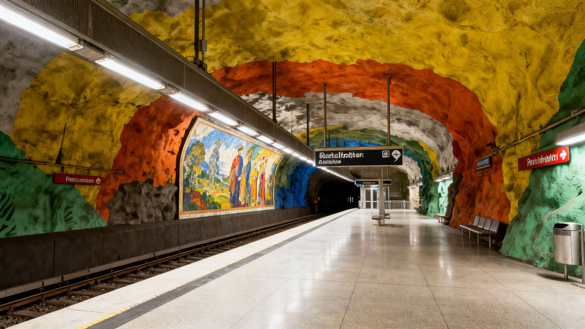
And then there's the Blue Line. This is arguably the most famous of the three, renowned for its dramatic stations carved directly out of the bedrock. It’s often called the "art line" because its stops feel less like transit hubs and more like subterranean art galleries. It runs from Kungsträdgården in the heart of the city out to the northwestern suburbs.
The Blue Line’s two branches, Lines 10 and 11, opened in 1975 and now serve a combined 330,000 riders daily. A few of its can't-miss stations include:
The Stockholm Metro as a whole serves 1.2 million passengers daily across its 100 stations and has been a vital part of the city since it first opened in 1950. For a deeper dive into the history and ridership of each line, you can find more detailed stats at Metro Line Hub.
Getting around Stockholm's metro is a breeze once you get the hang of its excellent map. Whether you're the type who likes a physical map in hand or prefers a digital version on your screen, you've got plenty of options to navigate like a pro.

For a classic, battery-free experience, you can pick up a free, foldable paper metro stockholm map at any SL Centre, the official public transport offices. You'll also spot them in ticket booths and at info desks in the big stations like T-Centralen, Gamla Stan, and Slussen. It's always a good idea to have one as a backup, especially if you're trying to save your phone's battery for taking photos.
If you want real-time information, digital maps are your best friend. The official SL app (short for Storstockholms Lokaltrafik) is easily the most powerful tool you can have. Think of it less as a static map and more as a complete journey planner in your pocket.
With the app, you can:
Beyond the official app, familiar tools like Google Maps have Stockholm's public transport data fully baked in. This is a fantastic option if you already use it for everything else, as it smoothly blends metro directions with walking routes to give you true door-to-door guidance.
Here’s a crucial tip for any traveller: always have an offline map. Before heading out, jump on the official SL website and download the latest metro map as a PDF. Save it right to your phone. This way, you'll always be able to check your route, even if you lose your signal underground.
Using the map itself is pretty straightforward once you understand the basic logic. First, find your current station and then spot your destination. Trace the coloured line that connects them.
If you need to switch lines, just look for the stations where different colours cross over. T-Centralen is the main hub where all three lines meet, so you'll likely get familiar with it quickly.
And here's the most important part: always check the final destination shown on the front of the train. For instance, if you're at Gamla Stan on the Green Line and need to go north to Odenplan, you’ll want a train heading towards Hässelby Strand, Åkeshov, or Alvik—not one going south towards Farsta Strand or Skarpnäck. This one little check saves you from going the wrong way. Simple as that.
The Stockholm metro map you hold in your hand today is a masterclass in clean, functional design. But it wasn't always this straightforward. Its story is a fascinating one, tracking the city's own growth from a geographically literal representation to the elegant schematic we know and love.
Back in the 1950s, when the system was in its infancy, the maps looked completely different. They were much more literal, with lines that twisted and turned, closely following the actual shapes of Stockholm’s islands and coastlines. While this gave riders a true sense of the city’s geography, it quickly became a cluttered mess as the network expanded.
The real turning point came as Stockholm grew. Planners and designers came to a crucial realisation: for a transit map, usability trumps perfect scale. The goal isn't to create a flawless street map, but to help people get from A to B with zero confusion.
This shift in thinking led to a gradual move away from those winding, geographical lines toward the straighter, more abstract diagram we see now. It's a design philosophy that prioritises simplicity. By sacrificing exact locations for clear, colour-coded routes and evenly spaced stations, the modern map makes planning a journey almost second nature. This principle, where function dictates form, is a cornerstone of great design. You can see a similar approach in our article on the iconic Case Study Houses.
The map's journey from the 1950s to the 1970s was especially dramatic. The network’s roots began with pre-metro tunnels in the 1930s, but the first true metro line—the Green Line from Slussen to Hökarängen—officially opened on October 1, 1950.
As new stations like Farsta opened in the late 1950s, the maps started to adopt a more stylised look. A map from the mid-1960s captures this middle phase perfectly, with more stations but still holding onto some of those geographical curves. By the early 1970s, the transformation was complete. The map had fully embraced a stark, rectilinear style—a world away from the early coastline-hugging designs. If you're curious, you can see the map's visual changes over 13 years in this fantastic historical overview.
This evolution shows a deep understanding of the rider's experience. The designers knew that a passenger underground doesn't need to know the exact curve of a shoreline; they just need to know which line to get on and where to change trains.
Today's map is the product of decades of tweaking and refining. It stands as a proud example of Swedish design principles: functional, beautiful, and completely human-centred. It’s more than just a tool for getting around; it’s a piece of Stockholm's living history, telling the story of a city that planned its future with both precision and soul.
The metro stockholm map is so much more than a practical tool for getting around the city. Think of it as a treasure map, leading you through what is often called the world's longest art gallery. It’s true—over 90% of the metro stations are decorated with incredible sculptures, mosaics, paintings, and installations, turning a simple commute into a daily dose of culture.
This whole initiative kicked off back in the 1950s. The idea was simple but powerful: make art a part of everyday life, accessible to everyone, not just those who visit museums.
This artistic vision was woven right into the fabric of Stockholm's growth. The metro construction, which officially began in 1944, wasn't just about digging tunnels; it was part of a grander plan to build new neighbourhoods and connect people to green spaces. This beautiful blend of transit, housing, and public art really became a signature of Swedish design. It created a system that serves people on a practical level while also feeding their soul. If you're curious, you can read more about how Stockholm’s forward-thinking urban planning was a key influence.
Putting together your own subterranean art tour is surprisingly easy. All you need is a valid SL ticket and your map. While the Blue Line is famous for its raw, cave-like stations, you'll find masterpieces scattered across the entire network.
Here are a few standouts you won’t want to miss:
Exploring this underground gallery is a uniquely Stockholm experience. It’s a testament to the idea that public spaces should not only be functional but also inspiring, enriching the lives of citizens and visitors alike.
To see the most art without wasting time, a little planning goes a long way. A great strategy is to start at T-Centralen and ride the Blue Line just one stop to Kungsträdgården. From there, double back through T-Centralen and continue out on the Blue Line to see Rådhuset and then Solna Centrum.
After you've soaked that in, head back to T-Centralen and switch to the Red Line. Ride it north to visit Stadion and Tekniska Högskolan. The art you'll see often tells a story about Swedish culture and history, much like the designs in classic posters. For a glimpse into another side of Swedish artistry, check out our collection of vintage posters from Sweden.
The best part? A single metro ticket gives you 75 minutes of unlimited travel, which makes a short, focused art tour both affordable and incredibly easy to do.
Getting to grips with a new city’s transport system always throws up a few questions. To help you feel like a local using the Stockholm metro map from the moment you arrive, we’ve put together some quick, clear answers to the things people ask most. Think of this as your personal cheat sheet for a smooth journey.
This is one of the best things about Stockholm's public transport: it’s brilliantly simple. Forget the complicated zone systems you find in many other big cities. Stockholm uses a single-zone ticket system.
What does that mean for you? A single ticket gives you access to the entire SL network—metro, buses, trams, commuter trains, and even some ferries—for a full 75 minutes. You can hop on and off and transfer as much as you need within that window. This simplicity is a lifesaver and makes planning your trips with the metro stockholm map incredibly straightforward.
The best ticket for your trip really comes down to how long you’ll be in town. While a single-use ticket is perfect for a one-off journey, most visitors find that a multi-day pass offers far better value and lets you explore without constantly thinking about tickets.
Here’s a quick look at your main options:
For most tourists planning to do a lot of exploring, the 24-hour or 72-hour travelcards hit the sweet spot of convenience and value. You can just hop on and off wherever you please without a second thought.
For the most part, Stockholm's metro system is very accessible. The vast majority of stations are equipped with lifts (elevators) or escalators to get you from the street down to the platform without any hassle. On the official metro map, you’ll see accessible stations marked with a universal accessibility symbol.
That said, it’s always a good idea to check the SL app or website for real-time information before you head out. Occasionally, a lift might be out of service for maintenance, and the app will give you the most current updates so you can plan an alternative route if you need to.
The commitment to accessibility is a key part of Stockholm's public infrastructure. The goal is to ensure that everyone, including parents with strollers and individuals with mobility challenges, can experience the city and its unique underground art gallery.
Absolutely. The metro stockholm map is just one piece of a completely integrated public transport network. The whole system is designed for seamless transfers between the metro (Tunnelbana), buses, trams (Spårväg), and even the local commuter trains (Pendeltåg).
Major metro hubs like T-Centralen, Slussen, and Gullmarsplan are also major interchanges for buses and other lines. Since your SL ticket is valid across all these modes of transport, you can easily switch from a metro train to a bus to reach your final destination. For instance, you might take the metro to a central station, then hop on a bus that drops you right at the entrance of a museum on Djurgården island. This integration makes exploring the entire city incredibly easy. If you have more questions about navigating Stockholm, you might also find our comprehensive frequently asked questions guide helpful for other aspects of your trip.
At Dalaart, we celebrate the artistry and heritage that make Sweden unique, from the masterpieces in the metro to the hand-carved Dala horses crafted in Dalarna. Discover an authentic piece of Swedish tradition by exploring our collection at https://dalaart.com.


.svg)


.png)


